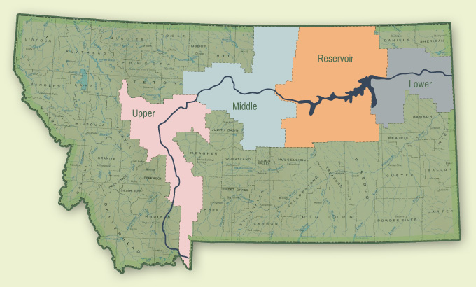
The Missouri River Corridor extends for 725 miles across Montana passing through the 14 counties and 15 conservation districts that form the Missouri River Conservation Districts Council. Each of the 15 conservation districts in the Missouri River Corridor has one supervisor as a voting member of the Council. Conservation Districts, through public elections, represent local residents’ views and concerns regarding natural resources – giving this Council a true grassroots perspective of Missouri River issues. The river corridor is divided into reaches that contain unique geographic, social and economic features that create conservation priorities for the region. Below is a list of the member conservation districts and their respective reaches:
Upper Reach
The Upper Reach of Montana’s Missouri River winds through Gallatin, Broadwater, Lewis & Clark and Cascade Counties. It begins at the Headwaters and provides some of the best cold-water trout fishing in the Lower 48. This diverse stretch of the river is home to multiple dams that provide water storage for irrigation and power generation. Canyon Ferry, in Broadwater County, is the largest reservoir in the Upper Reach.
Broadwater Conservation District
Cascade Conservation District
Gallatin Conservation District
Lewis and Clark Conservation District
Middle Reach
The Middle Reach consists of Blaine, Chouteau, and Fergus Counties. This reach includes the 149-mile stretch of the Missouri that was designated as a National Wild and Scenic River in 1976 as well as the Upper Missouri River Breaks National Monument, which was created by a Presidential Proclamation in 2001. The unique geology of the middle reach is showcased by white cliffs, badlands, and volcanic dikes. This reach is also celebrated as one of the longest remaining free-flowing stretches across the entire length of the Missouri River.
Big Sandy Conservation District
Blaine County Conservation District
Chouteau County Conservation District
Fergus County Conservation District
Reservoir Reach
The Reservoir Reach includes Phillips, Valley, Garfield, and Petroleum counties and is home to some of the largest features along the river – the Fort Peck Dam, which is the largest hydraulically filled dam in the U.S.; the Fort Peck reservoir, which provides 25% of the storage for the largest reservoir system in the U.S.; and the Charles M. Russell National Wildlife Refuge, the 2nd largest National Wildlife Refuge in the continental United States.
Garfield County Conservation District
Petroleum County Conservation District
Phillips County Conservation District
Valley County Conservation District
Lower Reach
The Lower Reach of Montana’s Missouri River lies downstream from the Fort Peck Dam and includes Roosevelt, Richland, and McCone counties. In addition to being one of the longest remaining free-flowing stretches along the entire Missouri River, this reach is home to 155 privately-owned pump sites serving 53,000 acres of cropland that add more than $20 million to Montana’s economy.
McCone County Conservation District
Richland County Conservation District
Roosevelt County Conservation District